New Features in Release 8.0
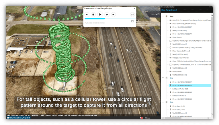
Our completely redesigned presentation tool GUI is more intuitively organized to simplify your workflow, streamlining the process of creating and customizing your settings like captions and speed for each action. The revamped Presentation Tool features 'steps,' which function as chapter-like headings that organize your presentation actions and offer increased flexibility in displaying your presentation. With the new presentation tool, you can easily add locations to your route or display objects simply by dragging them from the Project Tree into the Presentation Editor. New presentation operations have been added as well, including the option to enable contour and slope maps, as well as display shadows.
New 3D Mesh Layers Export Options
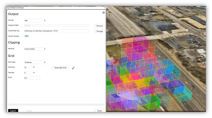
TerraExplorer 8.0 introduces significant improvements to 3D Mesh Layer Export functionalities. Users can now export entire mesh layers or specific sections to a range of data types, including 3D models (in OBJ, DAE, GLB, and FBX formats), LAS point cloud layers, and ATAK files. The updated Export tool offers robust control over multiple aspects of the export process, such as grid type, grid size, area selection methods, and coordinate system adjustments. Importantly, the tool supports both 2D grids and 3D boxes, enabling you to manage complex three-dimensional data and allowing features like tall buildings or utility poles to be vertically segmented into multiple files.
Uncover the potential of augmented reality (AR) visualization for collaborative decision making in the battlefield and headquarters. Our new HoloLens plug-in allows you to view the TerraExplorer 3D view as a lifelike 3D hologram through HoloLens 2 immersive headsets. This mode offers a virtual table whose dimensions can be customized and whose location is determined simply by the placement of a QR code, simplifying the setup process. With support for head tracking and intuitive controls as well as multi-user support, users can effortlessly navigate and analyze their 3D environment, for more informed tactical planning and strategic execution.

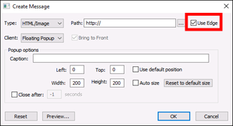
Skyline now offers the option to utilize Microsoft Edge for rendering advanced HTML and JavaScript within containers and popup windows. This feature gives users the option to load web pages that incorporate new technologies not supported by the IE browser control. Users now have the flexibility to choose between this newer Edge browser and IE (legacy) for displaying content.
![]()
Google Earth 3D Tiles
TerraExplorer 8.0 now provides enhanced support for the new Google Earth Photorealistic 3D Tiles service, covering more than 2,500 cities across the globe. You can seamlessly combine your high-resolution PhotoMesh 3D mesh models with the Google Earth background for a comprehensive 3D viewing and analysis experience. Utilize the TerraExplorer 'Load 3D Tiles' option, along with your Google API key, to integrate Google Earth models.

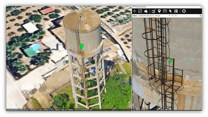
Photo Inspector's latest updates enhance inspection workflows. Key improvements include:
§ Performance Boost: While Photo Inspector continues to support various photo formats, a significant enhancement is the newly added option to stream the multi-resolution, tiled SMPT format generated by PhotoMesh. These optimized files are published to SkylineGlobe Server, facilitating faster online photo viewing by minimizing the necessity to load the entire photo.
§ Flexible Inspection Layers: Photo Inspector now supports enterprise-level inspection layers not initially created within the tool, while also freeing you from the constraints of its predefined attribute fields.
§ Offline Kit Publishing: The new "Extract and Publish Area as Offline Kit" option lets you publish your 3D models alongside the source photos used to create them in PhotoMesh’s aerotriangulation process, increasing offline accessibility.
§ BIM Attribute Information: Easily include information on a mesh model such as material information or geometric data within your inspection reports using new mechanism to copy the relevant attribute information from the associated BIM model.
Improvements to Analysis Tools
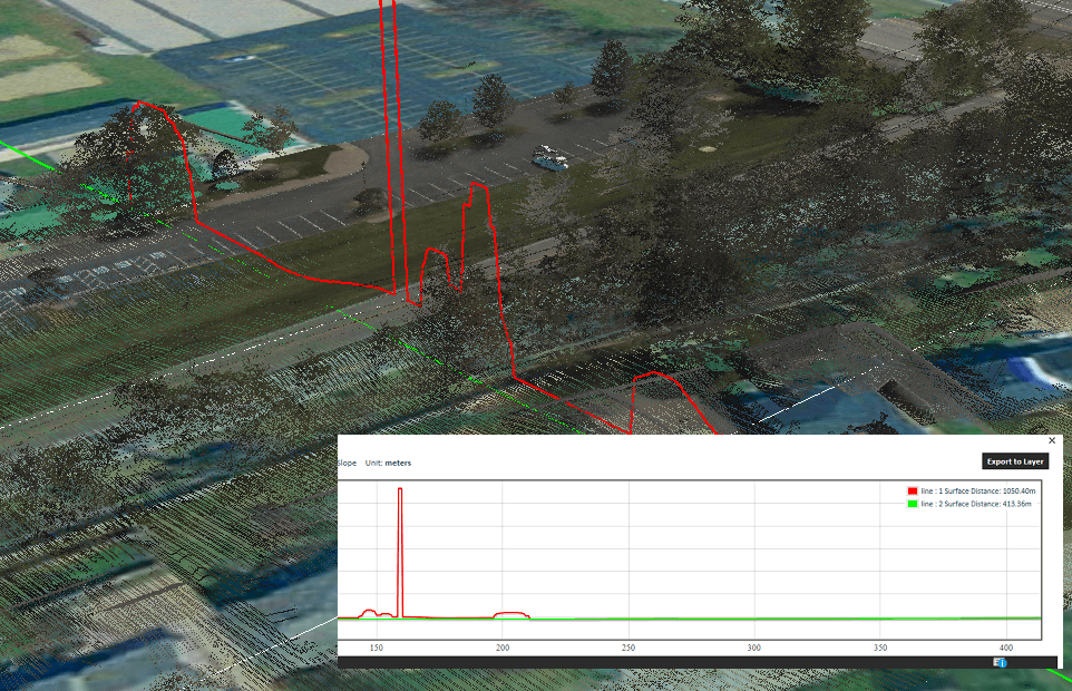
We've upgraded the Terrain Profile tool by adding a new Compare Mode, which allows for side-by-side terrain profile analysis of two different layers on the same graph. To ensure precise calculations, visibility for all other layers is temporarily disabled during this comparison and restored afterward. An additional enhancement links the terrain profile graph to the 3D Window - when hovering over any point in the terrain profile, a corresponding symbol is displayed in the 3D Window, pinpointing the exact location on the graph line.
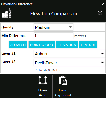
The Elevation Comparison tool has been updated to consolidate and extend its layer comparison functionalities. You can now evaluate elevation differences between two layers of various types: elevation, feature, point cloud, or 3D mesh.
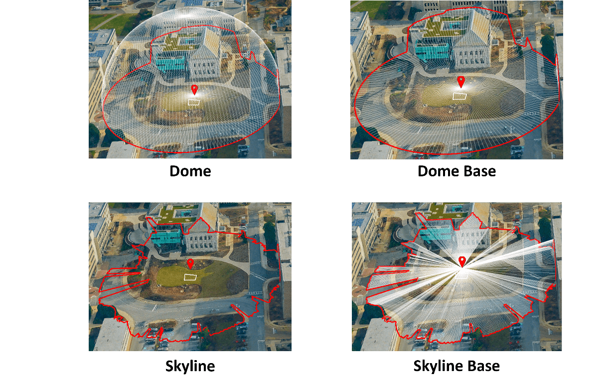
A new "Skyline Base" output type has been introduced as a variant of the existing "Skyline" output type. This enhancement adds lines that radiate from the viewer's position to the perimeter of the ring, which is formed by the outline of the visible terrain and objects.
Working with SkylineGlobe Server
§ Integrated SSO Authentication: TerraExplorer users can now enjoy a simplified login process when accessing SkylineGlobe Server 8.0, thanks to the newly integrated Single Sign-On (SSO) authentication. This feature is compatible with commercial Identity Providers like Google Workspace and Facebook, as well as enterprise identity provider servers, all supported by the OpenID protocol. This enhancement not only eases the login process but also adds an extra layer of security.
§ Republish and Update Project: When publishing a project that was opened from SkylineGlobe Server, you now have the option to either publish it as a completely new project or update the existing one. When choosing to update, a new version is created on the server, ensuring that users always have access to the most up-to-date information. Administrators can manage which version to serve to TerraExplorer clients via the SGS Manager.
§ Dynamically Load Grid Shift (TIFF, GSB, and GTX) Files: TerraExplorer 8.0 introduces a more dynamic approach to managing TIFF, GSB, and GTX grid shift files, enhancing the transformation between coordinate systems with different datums. When your project's Well-Known Text (WKT) references a grid shift file that's missing locally, TerraExplorer now automatically downloads the required file from the connected SkylineGlobe Server. For users without a server connection, the default source is https://cdn.proj.org.
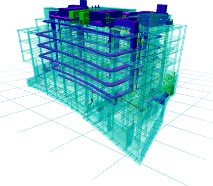
Enhanced Support for BIM Models
TerraExplorer 8.0 has bolstered its support for Building Information Modeling (BIM) by introducing compatibility with a broader range of IFC formats. These now include IFC 2x3, IFC 4, IFC 4x1, IFC 4x2, and IFC 4x3 (specifically IFC 4x3_rc1 and IFC 4x3_rc2). The coordinate system for BIM models is automatically read from the data, but users have the flexibility to change it as needed. The new release also extends support for planar projections. For data lacking built-in coordinates, users can now manually define the position for enhanced control and customization.
Stability Improvements and Bug Fixes
3D Tiles and Other Mesh Layers
Resolved various issues related to loading, import, and export:
§ Fixed crash of TerraExplorer when loading or converting certain 3D Tiles.
§ Corrected display issues affecting some 3D Tiles imported and converted to 3DML.
§ Addressed problem causing generation of incorrect bounding boxes when exporting to 3D Tiles.
Loading of Different Input Formats
Provided fixes for various input formats including DXF, GLB, and OBJ that did not load properly or caused TerraExplorer to crash.
API Improvements
Addressed multiple API issues including the following:
§ IWindow.PixelToObjects did not return on terrain lines.
§ IRouteWaypoints.GetWaypoint returned incorrect orientation information.
§ ITerrain.GetGroundHeightInfo returned inaccurate elevation values.
§ IAnalysis.QueryElevationBuffer sometimes returned inexact elevation values.
§ INavigate.SetPosition and INavigate.ZoomIn did not work properly in 2D and 2D North modes.
Publishing to SkylineGlobe Server and Offline/Local Kits
Resolved bugs related to projects published to SkylineGlobe Server and to offline/local kits:
§ Fixed incorrect application of feature layers’ geometry Z value.
§ Corrected issue causing exclusion of imagery layers from published kit.
§ Corrected the display of feature layer textures.
Importing BIM
§ Fixed incorrect application of coordinate system information.
§ Resolved bug that prevented editing of coordinate system information.
§ Fixed issue affecting correct positioning of some IFC models.
§ Resolved issue causing incorrect generation of bounding boxes of some imported IFC.
§ Corrected issue causing TerraExplorer to crash when editing BIM attributes from Attribute Table.
Point Cloud Conversions
Fixed bugs affecting conversion of LAS and e57 point clouds to CPT.
Photo Inspector
Resolved Photo Inspector bug that prevented moving and dragging photos inside the Photo Inspector window when working in Windows Server 2019 environment.
WMS Layers
Resolved issues causing incorrect or failed display of loaded WMS layers.
Scale and Rotate Tool
Scale and Rotate tool now works properly even for large mesh layers.